Home > North America > United States of America > New York > New York > Maps
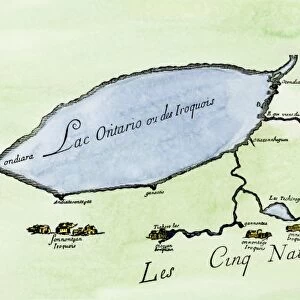
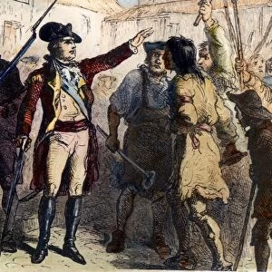
SIX NATIONS: MAP, 1771. Map of the country of the Six Nations, created by Guy Johnson for the Province of New York, 1771

![]()
Wall Art and Photo Gifts from Granger
SIX NATIONS: MAP, 1771. Map of the country of the Six Nations, created by Guy Johnson for the Province of New York, 1771
SIX NATIONS: MAP, 1771.
Map of the country of the Six Nations, created by Guy Johnson for the Province of New York, 1771
Granger holds millions of images spanning more than 25,000 years of world history, from before the Stone Age to the dawn of the Space Age
Media ID 6249283
1771 Boundary Canada Colony Johnson Lake Ontario Mohawk Nation New York Oneida Onondaga Pennsylvania Province Seneca Six Nations Territory Try On Cayuga Tuscarora Will I Am
FEATURES IN THESE COLLECTIONS
> Arts
> Landscape paintings
> Waterfall and river artworks
> River artworks
> North America
> Canada
> Lakes
> Lake Ontario
> North America
> Canada
> Maps
> North America
> United States of America
> New York
> New York
> Maps
> Popular Themes
> Six Nations
EDITORS COMMENTS
This print showcases a significant historical artifact - the "SIX NATIONS: MAP, 1771". Created by Guy Johnson for the Province of New York in 1771, this map provides a fascinating glimpse into the country of the Six Nations. The intricate details on this map offer valuable insights into the territorial boundaries and colonial influence during that era. It highlights various key locations such as Mohawk, New York, Pennsylvania, and Canada, emphasizing their significance within this vast region. The inclusion of Lake Ontario and several rivers further enhances our understanding of transportation routes and geographical features. Examining this map allows us to delve into the rich history of indigenous nations like Seneca, Onondaga, Tuscarora, Cayuga, Oneida - collectively known as the Six Nations. Their presence is vividly depicted through distinct markings on the map. Beyond its historical value lies an aesthetic appeal that draws viewers closer to appreciate its intricacy. The careful craftsmanship evident in every line and symbol reflects Guy Johnson's dedication to accurately represent these territories. As we admire this remarkable piece from Granger Art on Demand collection titled "SIX NATIONS: MAP" let it serve as a reminder of our collective past and encourage us to explore diverse narratives often overlooked in mainstream discourse.
MADE IN THE USA
Safe Shipping with 30 Day Money Back Guarantee
FREE PERSONALISATION*
We are proud to offer a range of customisation features including Personalised Captions, Color Filters and Picture Zoom Tools
FREE COLORIZATION SERVICE
You can choose advanced AI Colorization for this picture at no extra charge!
SECURE PAYMENTS
We happily accept a wide range of payment options so you can pay for the things you need in the way that is most convenient for you
* Options may vary by product and licensing agreement. Zoomed Pictures can be adjusted in the Cart.