Home > Europe > United Kingdom > England > London > Towns > West Kensington
Westway Flyover JLP01_10_00753

![]()
Wall Art and Photo Gifts from Historic England
Westway Flyover JLP01_10_00753
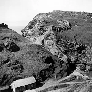
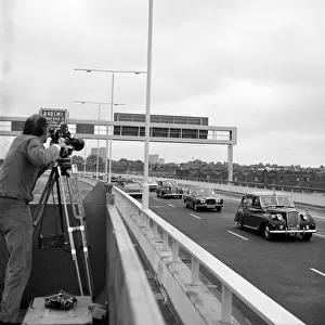
WESTWAY FLYOVER, A40, KENSINGTON AND CHELSEA, GREATER LONDON. An elevated view looking west at the junction between the Westway Flyover and the West Cross Route leading south.
Work on site for the Western Avenue Extension began on 1st September 1966, and the Westway as it became known was officially opened on 28th July 1970. The elevated highway connecting the A40 at White City to Marylebone Road in Paddington, at around 2 miles, was the longest in Europe. The construction was organised into six sections. Sections 1, 4, 5 & 6 formed the main flyover into central London with Sections 2 & 3 being the West Cross Route, running south from the junction in Section 1 near Latimer Road to Shepherds Bush. The West Cross Route was the first part of the London Motorway Box, part of the Ringway Project to encircle London with four concentric motorways. The Ringway Project was abandoned in 1975 with no further work on the West Cross Route. This photograph was taken at grid reference TQ
Historic England is the public body that champions and protects England's historic places
Media ID 24782949
© Historic England Archive
1970s Construction Flyover Road Transport
FEATURES IN THESE COLLECTIONS
> Europe
> Related Images
> Europe
> United Kingdom
> England
> Greater London
> Related Images
> Europe
> United Kingdom
> England
> London
> Boroughs
> Kensington and Chelsea
> Europe
> United Kingdom
> England
> London
> Towns
> Chelsea
> Europe
> United Kingdom
> England
> London
> Towns
> Kensington
> Europe
> United Kingdom
> England
> London
> Towns
> Marylebone
> Europe
> United Kingdom
> England
> London
> Towns
> Paddington
> Europe
> United Kingdom
> England
> London
> Towns
> South Kensington
> Europe
> United Kingdom
> England
> London
> Towns
> West Kensington
> Historic England
> Industry
> Engineering and Construction
> Building Motorways
> Westway Flyover
EDITORS COMMENTS
This print captures the iconic Westway Flyover in Kensington and Chelsea, Greater London. The elevated view showcases the junction between the Westway Flyover and the West Cross Route leading south. The construction of this remarkable structure began on September 1st, 1966, as part of the Western Avenue Extension project. Officially opened on July 28th, 1970, the Westway became Europe's longest elevated highway at approximately two miles in length. It connected the A40 at White City to Marylebone Road in Paddington. The construction was divided into six sections, with Sections 1,4,5 & 6 forming the main flyover into central London and Sections 2 &3 comprising the West Cross Route running south from Latimer Road to Shepherds Bush. Interestingly, this route was intended to be a part of a larger plan called the Ringway Project - an ambitious endeavor aimed at encircling London with four concentric motorways. However, despite its grand vision for urban development and improved transportation infrastructure within London, work on the West Cross Route was abandoned in 1975. Preserved by Historic England Archive and captured at grid reference TQ2371381144 by an anonymous photographer known only as Joh (not affiliated with any company), this photograph serves as a testament to both architectural achievement and unrealized ambitions for London's road network.
MADE IN THE USA
Safe Shipping with 30 Day Money Back Guarantee
FREE PERSONALISATION*
We are proud to offer a range of customisation features including Personalised Captions, Color Filters and Picture Zoom Tools
SECURE PAYMENTS
We happily accept a wide range of payment options so you can pay for the things you need in the way that is most convenient for you
* Options may vary by product and licensing agreement. Zoomed Pictures can be adjusted in the Cart.