Home > Arts > Artists > T > John Tallis
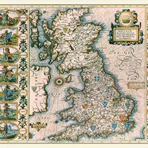
British Isles 1851

![]()
Wall Art and Photo Gifts from MapSeeker
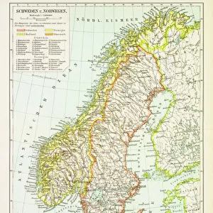
British Isles 1851
A fine facimile artworked from an antique original map of The British Isles, issued as part of the 1851 edition of John Tallis and Companys " The Illustrated Atlas and Modern History of the World"
Welcome to the Mapseeker Image library and enter an historic gateway to one of the largest on-line collections of Historic Maps, Nostalgic Views, Vista's and Panorama's from a World gone by.
Media ID 20347499
© Mapseeker Publishing Ltd
Historic Map John Tallis John Tallis Map Tallis Tallis Map British Isles
FEATURES IN THESE COLLECTIONS
> Arts
> Artists
> T
> John Tallis
> Maps and Charts
> Early Maps
> Maps and Charts
> Related Images
> Maps and Charts
> World
> MapSeeker
> Maps from the British Isles
> British Isles Map PORTFOLIO
EDITORS COMMENTS
This stunning print showcases a fine facsimile artworked from an antique original map of the British Isles, dating back to 1851. The map was originally issued as part of the prestigious 1851 edition of John Tallis and Company's "The Illustrated Atlas and Modern History of the World". With intricate details and exquisite craftsmanship, this historic map offers a glimpse into the past, capturing the beauty and complexity of the British Isles during that era. It is a testament to John Tallis' expertise in cartography and his dedication to providing accurate geographical representations. As we gaze upon this old isles of Britain map, we are transported back in time, imagining how life must have been in these lands over a century ago. Each line on this tallis map tells a story - marking cities, rivers, mountains, and coastlines with precision. John Rapkin's contribution to this masterpiece cannot be overlooked either. His artistic touch adds depth and charm to an already captivating piece. Together with Tallis' vision for accuracy in mapping, they have created something truly remarkable. Whether you are a history enthusiast or simply appreciate beautiful artistry, this historical map will undoubtedly captivate your imagination. Display it proudly on your wall or use it as inspiration for further exploration into the rich heritage of Great Britain.
MADE IN THE USA
Safe Shipping with 30 Day Money Back Guarantee
FREE PERSONALISATION*
We are proud to offer a range of customisation features including Personalised Captions, Color Filters and Picture Zoom Tools
SECURE PAYMENTS
We happily accept a wide range of payment options so you can pay for the things you need in the way that is most convenient for you
* Options may vary by product and licensing agreement. Zoomed Pictures can be adjusted in the Cart.